THE SYSTEM OF TRADITIONAL KNOWLEDGE IN THE MEDITERRANEAN AND ITS CLASSIFICATION ACCORDING TO THE DIFFERENT SOCIAL FORMATIONS
PIETRO LAUREANO
Representative for Italy in the UNCCD Science and Technology Committee
This report was prepared for the Secretariat of the UNCCD and presented at the “ad Hoc Panel Meeting” on Matera’s Traditional Knowledge from 15 to 18 July 1999.
It was subsequently presented at the meeting of the Science and Technology Committee in Bonn from 27 to 28 July 1999.
The Committee welcomed the report and asked the secretariat to make it available for the third session of the Conference of the Parties.
This report was disseminated during the Third Conference of the Parties held in Brazil from 16 to 18 November 1999.
Objectives of the study
- Define the characteristics of traditional knowledge;
- Studying the criteria according to which traditional knowledge should be classified;
- Compile an inventory of traditional knowledge in the Mediterranean area and indicate the techniques used successfully;
- Verify the different uses of traditional techniques by integrating them with modern technologies;
- Formulate Proposals and Recommendations
TRADITIONAL TECHNIQUES OR LOCAL SCIENCE SYSTEMS?
In the Second Conference of the Parties held in Dakar in October 1998 (COP 2), the Convention Secretariat has spread and proposed to the Science and Technology Committee’s discussion the synthesis work undertaken by the reports received from different countries on traditional knowledge and Expert missions specifically sent.
The study (ICCD / COP (2) / CST / 5) proposes the inventory of traditional knowledge as a list of 78 items of techniques or practices grouped into 7 different themes:
- Combating wind or water erosion (8 items);
- Water Conservation Organization (14 entries);
- Improvement of soil fertility (20 voices);
- Protection of vegetation (9 voices);
- Forestry (5 items);
- Social Organization (9 items);
- Architecture and Energy (13 items);
The structured inventory is motivated by the need to synthesize a very large and progressively expanded subject, with elaborated charts on the different techniques and procedures, which is a useful repertoire of traditional knowledge.
However, classification based on separation for goals and functions is likely to impede the topic and not to grasp the meaning and mode of traditional techniques. Traditional and local knowledge is always part of a complex system and therefore can not be reduced to a list of technical solutions and limited to a set of distinct applications according to the results to be obtained. Their effectiveness depends on multiple factors interactions. These should be carefully considered if you want to understand the achievements historically realized through traditional knowledge and understand the logic for contemporary reproduction.
Every traditional practice is not a gimmick to solving a single problem, but it is always an elaborate, often multifaceted method that is part of an integrated approach (society, culture, economics) closely linked to a world-based approach to accurate resource management locals.
A terracing, for example, is at the same time a way of protecting a slope, rebuilding the soils, collecting water. It works within a social organization and a shared value system that supports it and which in turn is based on it. In arid areas, what appears to be a network of narrow streets is actually, at full moments, an important flow channeling device that fulfills the different functions according to seasonal trends.
Modern technology seeks immediate effectiveness through strong knowledge specialization managed by dominant structures capable of mobilizing resources outside the environment. Traditional knowledge measures its functionality over the long and long term by using shared knowledge, created and handed down through generations and social practices, and utilizes renewable internal inputs. Thanks to modern technology, for example, deep wells were dug by pumping surface water with verifiable results, but draining nearby resources, and sometimes jumping into fossil water pockets, determine full exhaustion in time.Traditional knowledge, on the other hand, uses meteoric water collecting systems or superficial springs exploited using the same gravity or withdrawal methods that allow for the recovery of the resource and its long-term durability .
While modern technology methods are separating and specializing, traditional knowledge combines and integrates. In modern conception, agriculture and cities are three completely separate sets that respond to distinct needs: timber, food, housing. They cover specialized scientific systems: forestry, agriculture, urban planning.
In local knowledge, the world of plants is not artificially distinguished between the forest supplying commercial timber and the agricultural area that provides food (Shiva 1993 p18) .Forest, fields and dwellings are unitary ecological sets. Forest and other seemingly non-productive marginal areas such as steppes and marshes provide important food supplies and provide water, feed and fertilizer for agriculture. In them you can also conveniently live.
The traditional city, in turn, integrates with agriculture by replacing in the deserted areas the forest for the acquisition of fertilizers produced by the organic waste of the inhabitants themselves and for the production of water collected on the roofs of the houses. Fields through the so-formed humus give colloidal material indispensable to construction in the case of raw earth towns. The excavation resulting from the removal of the earth is used as impluvio for water, pit for the transformation of excrement into humus, a perimeter protected production garden from the excavation walls. And so on in a continuous cycle of activities where the result of one is the basis for the other’s achievement. The architectures, in every smaller constructive detail, conform to this need.
In Shibam , the city’s oasis of raw land, in the south of Yemen , the planimetry of the town is organized according to the possibility of collecting, through a special two-way cabinet, the excrements of the indigenous inhabitants to transform the sands into fertile soil. This principle so similar to the functioning of nature in which any residue of a system is used by other systems and there is no concept of rejection or the possibility of resorting to external resources is what allowed the survival of human groups in history
Multipurpose polyfunctional techniques have guaranteed success in adversity as well. Collaboration and symbiosis through the reuse of all that is produced within the system has allowed autopoiesis, self-production, self-propagation development, independent of exogenous or occasional factors.
Intensification of resources and socio-cultural formations
Do not reduce traditional knowledge to a whole set of techniques means reading these in the overall environmental, productive and cultural environment of societies. The inventory of technologies, knowledge, and traditional and local practices thus becomes the study of social formations. These maintain a relationship with nature through a series of resource-use practices that make up their technological dimension and are an integral part of the cultural system.
Such knowledge, technologies and artificial transformation of the environment make it possible for populations to draw from this a growing number of resources compared to those available naturally. Benefit amplification centers are being created that are able to provide optimal living conditions that are subject to further positive changes. Communities in equilibrium with resources remain stable for long periods of time. Or they can undergo profound transformations, diluted in large temporal arcs or focusing on more sudden status revolutions, which determine the transition from one social formation to another.
The object of study is thus enlarged to the history and knowledge of all humanity, without limits of space and time. For these reasons, there is no claim to propose an exhaustive inventory, but to bring out a system, a theoretical reference grid, and a classification scheme within which new contributions will progressively be placed.
The traditional knowledge system is reconstructed following the usual classification of social formations adopted in archeology and anthropology in: hunter-gatherers ; Cultivator-breeder ; Agri-pastoralusers of metals . To these three categories are added two superior syntheses consisting of complex traditional social systems of intensification and knowledge integration (Table 3) . In them the technologies of the previous social groups appear stratified and combined in a diverse way according to different social and environmental situations.
No images were found
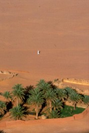
The first synthesis of complexity is the oasis understood as an artificial achievement due to perfect environmental wisdom. In the desert the environmental context of aridity is interrupted by specific situations that create niches and micro environments in contrast to the overall cycle. A small depression collects moisture, a rock gives shade, a seed sticks. They evoke so favorable dynamics: the plant generates its own protection against the rays of the sun, concentrates the water vapor, attracts insects, produces organic matter, builds the soil from which it feeds itself.
You create a biological system used by other organizations that make their contribution. A symbiosis, a microcosm, is the result of co-existence. Using these processes, the Sahara people make the oases.
At their origin there is often a single palm planted in a soil digging and surrounded by dry branches that protect it from the sands. Over time, extensive cultivation takes place along terraced canyons or green archipelagos immersed in the dunes thanks to diversified and complex techniques of water production, territorial organization and microclimate determination.
Both the dimensional scale operates the same principle, the oasis effect : the establishment of a virtuous circuit capable of self-propulsion and self-regeneration. The process can be assumed as a model, and it is possible to generalize the term oasis to all situations, even in non-desert areas, of the creation of living islands according to the following definition: oasis is a human settlement in inclement geographic situations that uses rare resources, Locally available, to trigger a growing amplification of positive interactions and to achieve a fertile and self-sustaining environmental niche whose characteristics contrast the unfavorable surrounding (Laureano 1988) .
 There are therefore the oasis of raw land in the Sahara, but also oasis of stone in the rocky highlands, oasis of sea in the islands. Even in rainforests can be defined as oasis systems the Mayan settlements in the Yucatan that did not have surface waterways for the karst environment. Oasis of intensification niches are found throughout the Mediterranean. These habitat systems are particularly present on the southern shore of the Mediterranean and southern Mediterranean, islands and peninsulas, in all those situations where alternate and catastrophic climatic conditions with precipitation concentrated in a few months of the year and Arid seasons, require careful management of water resources not present in the free state, lakes or fluvial waters and technological advances to control their variability over time.
The next level of complexity is the urban ecosystem that is the model of the oasis that has become a city. These are large city caravans in the desert or urban obelisks that surpass the small size of the oasis. Irrigated areas are created using geomorphological conditions favorable in precise geographic systems. A great capital dominates each unit of landscape: isolated basins in the desert; Large plains between mountain peaks; Oasis strips along hydrographic networks; Crossroads of distant, international or intercontinental roads. But also traditional habitat systems that make the best use of available resources become historic centers of regional significance and urban features.
The classification allows us to follow in a chronological fashion the continuous process of accumulation and stratification of knowledge since the first three social groups correspond to the passage from the Paleolithic to the Neolithic and the Metal Age to the higher levels of complexity of oases and ecosystems urban. But if this is useful for the purposes of classification, it would be misleading to desume a conceptual indication. In our model, the types of social formations do not represent evolutionary stages of human history as rather conditions that characterize certain periods but which can coexist in the same historical moments and in fact realize over time continuity, overlaps and interpenetrations. Socio-cultural formation prevailing at the dawn of human history is still largely present in human groups where the practice of knowledge similar to those derived from paleontology and archeology studies can be found. There are, of course, the differences, but these are largely already present among communities belonging to the same type of social formation in the same historical period. Forms of socio-cultural formation should not be understood as universal characters: they change according to the geographical context and the specificity of the dominant conceptions. The need to separate
And classifying is a scientific requirement, but hides the overlapping and stratification of technological and cultural levels of time, the simultaneity of diverse environmental climatic conditions, the synchronous existence in the history of human experiences and dissimilar social patterns. Both the environment and the world’s conception of a community contribute to the creation and maintenance of specific characters.Both of these factors vary continuously over time and from place to place by creating and preserving cultural diversity.
Application of the model to an exemplary Mediterranean case study:
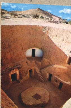
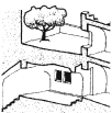
The Sassi of Matera
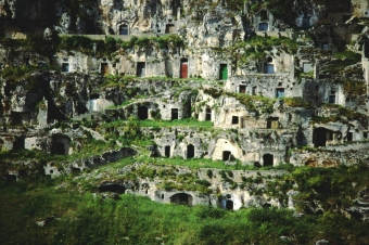
Sassi (Matera, Italy)
An example of traditional ways of using resources in the Mediterranean is the case of the Sassi of Matera and the similar settlements of the Murge Plateau up to Taranto .
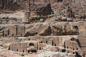
Petra (Jordan)
The local knowledge system can be found in a very wide range of situations from the troglody complexes of the Loire Valley, France, Petra, Jordan, to cities excavated in the limestone rock of Cappadocia, Turkey, to the underground settlements of Matmata in Tunisia , The villages along the canyons of Algeria and Morocco to the water techniques of Andalusian and Nabatean agriculture.

Cappadocia (Turkey)
Cities are built on the edges of deep valleys, the Gravine , which have sporadic or no flowing water. Settlements are not located in the bottom of the canyon as we should expect if this is to provide the water resource, but up, along the plateau and its steep slopes .
Matmata (Tunisia)
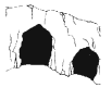
It is the water of the skies, the rain and the frost, collected in the drainage and in the caves the resource of the complex troglody labyrinths of the Sassi of Matera and of the other stone cities of the Gravina (Laureano 1995) . The stratification of traditional knowledge based on the classification adopted by social groups, hunters, gatherers, growers, breeders and agri-pastors shows the progressive determination of a complex system of knowledge and proper use of resources to the creation of the oasis of Stone and urban ecosystem.
Hunters; gatherer
Collection of water in caves for dripping and percolation
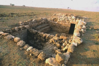
Human activity has been attested since the Paleolithic period, as evidenced by the discovery of a large number of stone finds in the Cave of the Bats and an entire omnipotent skeleton found in a karst cavity near Altamura dating back 250,000 years ago.

Collecting rainwater in the puddles
The Cave of the Bats is a natural formation, but its structure consists of a tunnel with an entrance facing the slope and the other end emerging through a karst swallow on the floor is a model for successive artificial realizations.
Farmers; breeders
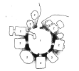
Villages with large moats to drain the ground and collect water (multifunctionality of the system)
With the neolithic, the techniques of excavation of the limestone plateau and the collection of the waters that have in the Sassi continuity up to the present time appear. Bell cisterns, horseshoes, canals are enclosed in deep moats forming circles and ellipses and for this they are called truncated villages.
It is likely, however, that ditches did not have a defensive purpose and were rather functional for neolithic farming and cultivation practices. From the analysis of the aerial photographs that show the perimeters of the thicker vegetation, rather drainage systems (Tinè 1983, Leuci 1991) appear to collect water or humus or corral labyrinths needed for agropastoral life practices. The recent excavation of the neolithic complex of Casale del Dolce near Anagni provided an authoritative confirmation of this hypothesis (Zarattini and Petrassi, 1999) .
Agro Shepherds
Cave excavations for cultural purposes and for catching water
The age of metals provides new tools that facilitate the excavation of caves and cavities. These with the worsening of the environment are becoming more and more suitable for human settlements. In fact the progressive disappearance of the vegetable mantle leaves the villages on the surface without shelter, the defenseless soils and causes the shortage of wooden materials for construction and heating. The climate sees the alternation of cold winters and torrential summers.
Well done
Water shortage, completely absent in rivers or on slopes and present only in violent and concentrated rains, makes meteoric water collection and underground conservation practices indispensable. Originated in the Neolithic mining techniques of the mines, the dwelling type of the courtyards from which the radial galleries spread.

Terraces for soil conservation and plantations
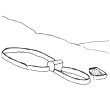
The pattern spread to other distant areas such as Matmata in Tunisia and the Chinese arid plains is at the origin of the court house used by the Sumerians in the classical and Islamic world. The house found near the Neolithic site of Murgia Timone overlooking the Sassi of Matera shows the advantages of this constructive type. The rectangular shape similar to Cretan Megarones is divided into three spaces formed by two open spaces and a third hypogeum.

Dry walls
The court acts as an impulse to water and open and sunny space, but perimetrically protected, for food processing. The end part, used to collect waste and create humus, is the garden dug into the indispensable stone due to the soil’s poverty and the need to repair the plants. The cavities have a constant temperature throughout the year, providing ideal shelter for men and animals, grain storage and water retention.
It is interesting to note that after the discovery of this structure and its release from sediments the tank in the hypogeum began to fill with water in the absence of rain. The device then began to operate using capillary infiltrations and condensation.
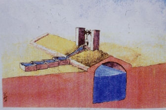
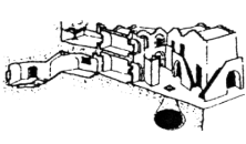
Model of tank and house found in Murgia Timone, Matera
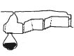
They relate to water-gathering practices for functional and ritual purposes, also the bronze age tumulus formed by a double circle crossed by a corridor bearing the central excavated environment. It is significant, in fact, that these structures have been inserted right along the excavation of the archaic Neolithic fences, abandoned at the time of these accomplishments, but still function as moisture conveyors.

Floors and lines of stones
The works found in Matera are all too similar to prehistoric structures formed by Tahunas and hypogean environments of the Sahara. These are the so-called solar tombs consisting of concentric rings around a mound. They can be ancient methods of collecting moisture and frost and relate to cults related to such practices.

Megalithic monuments; Humidity condensers
For the same purpose, the dry stone structures spread in the arid lands of the Puglia can be interpreted, where the accumulations of stones collect the night brine and provide the soil with moisture. In fact, the roots of centennial olive trees are all facing the walls that characterize the agrarian landscape. Consequently, the structures of condensation and water conservation include walls, mounds, trulli and limestone rock masses called specimens . The devices perform their function both day and night.
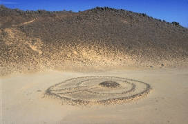
Prehistoric structures near Matera and Sahara
Under the sunny sun, the wind with traces of moisture infiltrates the interstices of the cumulus of stones which have a lower temperature in the interior because it is not exposed to the sun and cooled by the underlying hypogeum chamber. Lowering the temperature causes condensation of drops that fall into the cavity. The same accumulated water provides additional moisture and freshen up amplificand
Or the effectiveness of the condensation chamber. During the night the process is reversed and condensation occurs externally but produces similar results. On the outer surface of the coldest stones condenses the moisture and deposits the frost that slides in the interstices and it collects in the underground chamber.
Stone oasis

Canyon and gravine settlements: Vertical integration of systems
Developing the original prehistoric techniques, Matera’s Sassi is an adaptive habitat system that combines the different principles of water production: capture, distillation and condensation. During violent rains, terraces and water collection systems protect the slopes from erosion and convey gravity through the cisterns into the caves.

Terraces: realization of ecosystems
In the dry season, excavated cavities work at night as aspirators of atmospheric humidity condensing in the hypogeal tank cistern, always full even if not connected with external ducts. Many hypogeous plans are created overlapping by the long tunnels that sink in the subsoil. The inclination allows the rays of the sun to penetrate to the full when there is more need for heat. In winter, in fact, the rays are more oblique and hypogea penetrate. In the hot season, the sun closest to the zenith hits only the entrances of the hypogeans leaving them fresh and damp.
Housing in traditional, functional materials for energy saving, water collection and recycling
There are over ten floors of overcrowded caves with dozens of bell cisterns that are joined together by canals and water filter systems. As in the Sahara oasis, the local knowledge system allows, in a water-free environment, a viable condition through the proper use of techniques and their perfect interaction with the environment.
Urban ecosystem
Urban ecosystem
Medieval monasticism provides new lymph to this archaic fabric. The hermits, the parishes, the farmhouses placed at the checkpoints of the hydraulic works are the poles of the urban growth process. Around the two main drains called “Grabiglioni” that provide cultivable land and humus through the collection of sewage, the two urban areas are called Sasso Caveoso and Sasso Barisano.
In the center is the Civita, the fortified acropolis, the ancient refuge in case of danger, on which the Cathedral is built. At the edge of the plateau where are the big tanks and pits, the rock silos for the storage of grain, are located the workshops and craft workshops. The vertical movement of the city allows the use of gravity for the distribution of water and protects it from the winds that sweep the plateau. Matera is embellished with hundreds of rock churches excavated in the rock and decorated with magnificent Byzantine frescoes or built on the floor with monumental facades carved in tufa according to the style of the medieval, classical or baroque period. But the intricacy of the narrow streets, the net of stairs and underground passages continues to follow the ancient hydraulic structure. So today the urban plot of the Sassi of Matera can only be explained from the original matrix of hypogeums, cisterns and terraced gardens. From that traditional system of knowledge that has allowed the continued intensification of the use of resources without exhausting them.
The traditional knowledge system in the Mediterranean
The Mediterranean has three of its sides in contact with areas where humankind has had to confront the phenomenon of aridity, has islands completely devoid of subterranean and superficial waters that have been places of development of elaborate civilizations and even in its areas Northernmost, has seasons and places from alternate and catastrophic climatic events.
Hence, they present most of the traditional water management, water conservation and water management systems, and slope protection systems and soil design with different characterizations and accentuations in the environmental context.
There are also devices such as the underground drainage tunnels of more specific oasis, north africa or oriental, in southern Italy and in Spain carried by Islamic civilization or even of ancient origins. The numerous techniques of water saving of Nabatean agriculture , caves and Condensation wells, rainbow-lined stone arrays, the underground dams are widespread, as well as in the Negev across the Mediterranean. They have their synthesis of urban ecosystems in Petra (Jordan), but are present in Tunisia, Libya, South Italy and particularly in the islands transmitted by prehistoric traditions or diffused by the latest exchange currents.
The techniques of Andalusian agriculture in Spain represent a moment of great intensification of these practices related to Islamic civilization. In Ibiza Island there is an irrigation practice of this type of exemplary ingenuity called feixes . The feixes are a cultivation system based on a typical hydraulic organization. The fields are divided into narrow and long rectangular particles separated by a network of channels that have the dual function of draining water when it is superabundant and collecting, sparing and irrigating the fields during droughts. Indeed, without these space organization work the area would naturally be marshy in some seasons and arid or invaded by salty seawater in others.
The system creates a self-regulating system that allows to cultivate both the marsh and the humidity environment intensively. The open air channels are about one meter deep and flow to a lower level of soil particles, so keep it dry from the water. The land excavated for the construction of the canals is used to raise the share of cultivated land. In warm times, when the soil evaporation is high, the particles absorb the right amount of moisture directly into the underground from the walls of the channels for osmosis and capillarity.
The process is favored by further underground pipelines built inside the particles. These underground canals are made of porous stones and pine branches covered by a layer of seaweed collected on the coast. The method ensures the functionality of the pipes for water intake and at the same time allows a certain permeability to release to the soil the amount needed to keep it wet.
Irrigation is thus done from the ground directly to the roots of plants. The technique permits the saving of the water resource which, by open irrigation methods, would be dispersed by evaporation.
Traditional techniques exist not only on the southern shore of the Mediterranean and in the southern parts of the European side, but also in northern areas such as France and even in the mountains of Switzerland where perticular geomorphological conditions determine conditions of aridity. The situation is due to the orientation of the mountain slopes compared to the dominant winds that drain all their humidity during the climb of the slopes and, past the top, slam the slopes downstream with high-pressure dry wind currents that dissipate the clouds. It is the phenomenon of the desertes of Piedmont that in the Swiss conditions creates valleys characterized by drought and aridity. These places in the Valais region and in the province of the city of Zion are marked by green pastures and rich grape cultivation. The landscape is not the result of natural conditions, but of the wise use of a traditional technique known as bisse .
They are made of wood or carved pipes that extend into high mountains up to spring springs and perennial glaciers and run for miles and miles with minimum slopes along the steep edges while maintaining a high proportion to channel the waters upstream of the ‘Natural sliding bed and irrigating with the only gravity use far valleys that would otherwise be completely free from water. The system is governed by social cohesion, corporations and water societies similar to those that run the Andalusian agriculture or the Saharan drainage tunnels. It generates, just like in North Africa and Spain, a particular landscape in which the location of settlements is determined by the plot and the outlet points of the bis channels.
The most widespread system that can be defined as the typical characteristic of the Mediterranean is that of the terraces found by the Middle East, Greece, through Italy to Portugal. Associated with the cultivation of the olives or that of the vineyard becomes a true element of landscape edification. The slopes and hills of the northern Mediterranean have weathered erosion over time and have the form we know through this titanic work and prolonged over time. Associated with dry walls, the heaps of stones (specchie), the tolos (trulli) architecture are the typical feature of the Puglia region in Southern Italy. In central and northern Italy with the terraced slopes of Amalfi and the Cinque Terre in Liguria give rise to urban ecosystems of great fascination and tradition. Sardinia and the island of Ibiza have systems of fields enclosed by dry walls called the “tanka” way from an ancient Mediterranean toponym.
On the plot of terraces and water systems, most of the Mediterranean ancient centers have been built. These inglobate and perpetuate the techniques of rainwater harvesting, protected vegetable gardens, habitual organic waste utilization habits, passive architecture and climate control methods for food conservation and Energy saving, recycling practices of food and residues. The aesthetic qualities we appreciate in ancient cities, the beauty of natural materials, the comfort of architectures and spaces, the organic relationship established with the landscape are due precisely to the intrinsic qualities of traditional techniques and the search for symbiosis and harmony in knowledge local.
Throughout the Mediterranean archaic societies, developed in economies lacking resources, have based it
Ro survival on the accurate and parsimonious management of natural resources. The intricate interpenetration between traditional farming and settlements makes traditional historic centers a key element in preserving the environment. In the Mediterranean space characterized by intense and historical anthropization, no part of the environment is completely natural but constitutes a cultural landscape in which historical centers are the crystallization of knowledge suitable for proper environmental management and maintenance.
Crises of traditional historic centers and desertification and degradation of Mediterranean soils
When the balance between resources and their productive use, harshly maintained over the centuries, is interrupted, the urban ecosystem collapses, triggering degradation of entire territorial areas. In the Mediterranean basin, in its islands and peninsulas, in Syria, Lebanon, Mesopotamia, Palestine, Arabia and North Africa, the sites of the oldest civilizations, where archaeological excavations reveal cities once surrounded by a luxuriant nature rich in flourishing fields and gardens , Are now abandoned and buried by the sands. The desertification process has been steadily increasing since 3000 years ago; Has been accentuated with the industrial era and has reached catastrophic dimensions over the last 50 years.
Continuous environmental degradation is not due to natural and climatic causes, but to the indiscriminate pressure on natural resources. Existence, production and consumption patterns, which have replaced traditional patterns in advanced countries, lead to total depletion of local resources by fueling the hypertrophic growth of developed areas through massive recourse to externally conveyed energies, first from the hinterland, Then further distant areas. This extends the destruction of plant and landscape assets and interrupts the millennial transmission chain through generations of knowledge appropriate to the environment. Their disappearance causes the end of the maintenance and government capacity of the space to which we must balance and harmonize the exemplary territories such as landscapes created by work and culture.
The urbanization of new areas corresponds to the abandonment and exodus from the ancient centers with the disappearance of territorial presidencies capable of proper management of the environment. There is a process of physical and social desertification. Architectural degradation, erosion of slope systems, salinisation of coastal soils cause depletion of human resources. Emigration, loss of identity, fall in values are cultural partners of desertification caused by the disappearance of the traditional knowledge system.
In modern societies the goods necessary for subsistence are provided by world trade and globalization. Both precious goods and consumer goods and often the same food come from far away. Small-scale companies also engage in the exchange of food and materials, but the resources that allow them to exist, most of the hunting products or crops are taken from the nearest environment. These are societies based on local livelihoods. The crisis of this model has made human settlements as environmental guardians become the destroyers.
Modern urban areas contribute to the desertification process directly and indirectly: directly because we can say that the same massive urbanization is desertification due to the cementation of vast natural surfaces; Indirectly through absorption and destruction in areas with strong demographic concentration of natural resources from the territory.
This close relationship between urbanization and desertification can be seen in both non-industrialized and developed countries.
In Africa in the Sahel areas where desertification is stronger, the process of degradation is triggered and extends just from areas of modern and accelerated urbanization that, for their needs, deplete the surrounding territory. In the Mediterranean, the extension of the desertification process is in direct relation to the crisis of historic urban centers, which, in a traditional landscape of natural habitats with strong natural and low resource consumption, replaces a model based on massive cementation, Energy expenditure and environmental pollution. Centralization in urban areas, increased demand for agricultural products and consumer goods leads to the abandonment of traditional cultivation systems and the introduction of new farming methods and policies based on monoculture. The eradication, loss, or redefinition of role-playing categories such as senior citizens and knowledgeable women lead to the depletion of resource management skills and the loss of traditional knowledge.
Recommendations: The traditional model for a new technological paradigm
The populations of the regions at greater risk of desertification and degradation and the accumulated knowledge are a great resource because the knowledge of localizing itself in the harsher environmental conditions and the existence of intact antique structures are a precious asset on which to build Of new sustainability models.
Mediterranean countries play a key role as a hinge between the most affected areas and the advanced economies. Historical settlements, traditional landscapes, local knowledge offer a rich example of solutions that need to be safeguarded and can be reproposed adapted and renewed with the contest of modern technology.
In their reuse is not the specific procedure, but the logic in it is enclosed. It must comply with the following principles:
- Enforcement of internal resources;
- Local management capacity;
- The non-high costs that can be spent locally;
- The preference of a high working component rather than capital;
- The close link with the environmental context;
- The production and consumption cycles that complement each other;
- The trend towards zero emissions, that is, the possibility that every activity will feed one another;
- Self-improvement and autopsies (self-productability);
- The multifunctionality and the interpenetration between technological achievements and cultural and aesthetic values;
- Accurate management of resources;
- The saving of places and energy;
- The management of the ecosystem;
The integrated project.
In southern Italy, traditional centers such as Matera were completely emptied by the inhabitants in the 1950s and 60s because they were considered outdated by modernity. They are now restored and repopulated by reusing traditional architectures built with local energy-saving materials, recovering rainwater in tanks, recycling waste. The process of enhancement has been triggered by the creation of a new paradigm: to interpret places regarded as symbols of poverty and poverty as genius spaces and models for the future. The abandoned slopes, upset by erosion and degradation of the soils, are restored with the system of dry walls and terraces

High-intensity employment measures retrieve ancient knowledge and implement consolidation of the slopes while at the same time creating a delightful garden area for the population and a cultural appeal. These projects become tourist attractions with additional benefits for the population.
Traditional systems have an archaeological, historical, anthropological interest and this aspect adds to them a cultural callback value that allows further economies. The process is extensible across the Mediterranean from the Casbah and the Medina of North Africa to the traditional Middle Eastern systems.
According to the logic of the traditional knowledge system a new environmental management model for the fight against desertification and soil degradation in the Mediterranean must be based on the following guiding idea:
In rural areas, agriculture is not a simple production system but an action that is necessary for the maintenance of the territory;
In urban areas integrate environment and cities and implement action plans for the realization of sustainable human settlement and the management of the city as an ecosystem.
Programs should focus on innovative actions in soil, water and energy resources management. In particular, it is necessary to:
- Give new addresses to those loans that have occurred that are causing destruction of local knowledge, fires, soil degradation, and landslide transformations;
- Promote and promote the traditional systems of production, collection and distribution of water;
- Foster traditional practices in the organization of production for integrated cycles;
- Incentivising autopoiesis programs and sustainability of the urban system;
- Promote integration systems between urban cycle segments (production, consumption, waste);
- Encourage the participation of populations by re-evaluating in particular the role of the elderly, women, children and marginalized groups and by organizing territorial networks between municipalities, territorial pacts, basin communities and parks.
The logic of local knowledge and the traditional layout of the territory must be reiterated as the protection and preservation of the quality of the typical Mediterranean landscape and in new forms and solutions to implement

A new and repository role of traditional rural systems for the conservation of the soils and the saving of resources, activities made sustainable through the integration of other economies such as cultural tourism and discovery, archeology and the fruition of the environment with The consequent proposal for conversion in this direction of agricultural methods, desertification factors and the rejuvenation of areas overturned by industrial agriculture; New integrated production, consumption and recycling cycles in the area
Urban development with the exploitation of ancient centers and the reuse of traditional materials and constructive techniques in new buildings, the creation of new neighborhoods based on the appropriate resource saving and use, and the re-development and environmental transformation of areas subject to urban or industrial desertification;
New-generation territorial planning programs that take into account the aesthetic, cultural and economic value of the landscape, understood as a specific quality of the Mediterranean area in general and Italian in particular, formed during a millennial relationship between humanity and nature , With the objective of consolidating its appearance through the typing of the characterizing elements and the innovative reproduction of traditional logic through soil enrichment, overflowing and resource saving.
Bibliographical references
AA. VV. Water Management, World Archeology , vol. II N. 3, February 1980.
AA. VV. 1996, Elles et L’Eau , UNESCO, Program Hydrologique Internazional, Paris, 1996.
Barker G., 1996, Farming the Desert, The Unesco Libyan Valleys Archeological Survey , Unesco Publishing, the Department of Antiquities, Tripoli, and the Society for Libyan Studies, London.
Cantelli C. 1994, Misconosciute functions of dry stone walls , in Humanism of stone , n. 9, Martina Franca.
Chaptal L., Laughter
Contre la sécheresse. The capatation of the vapeur d’eau atmosphérique , in La Nature , 60 and année, 1932/2.
Drower MS 1954, Supply of Water, Irrigation and Agriculture , in the History of Technology 1. Prehistory and the Ancient Empires , Turin, 1961 , 1992, Or. ed. A History of Technology , Clarendon Press, Oxford, VI
Gérard RD and Worzel JL, Condensation of Atmospheric Moisture from Tropical Maritime Air Masses as a Freshwater Resources , in Science, vol. 157, 15 September 1967.
Ginestous, Hhydogenèse aérienne au Sahara , in Revue agricole de l’Afrique du Nord , n. 670, juin 1932.
Hitier H., Condensateurs des vapeurs atmosphériques dans l’Antiquité , in CR des Seances of the Académie d’Agriculture de France, XI, 1925, p. 679 – 683.
Laureano P., 1988, Sahara, unknown garden , Joints, Florence, 2nd edition 1989 French edition Sahara jardin méconnu, Larousse, Paris, 1991.
Laureano P. 1993, Stone Gardens, Sassi di Matera and Mediterranean Civilization , Bollati Boringhieri, Turin, 2nd edition 1997.
Laureano P. 1995, The Reversed Pyramid, the oasis model for planet Earth, Bollati Boringhieri, Turin, 2nd edition 1998.
Laureano P., 1998, Proper Use of Natural Resources, Environmental Architecture and Hydraulic Technologies for Self-Sustainable Resorces-Sparing Projects, in Human Evolution , Vol. 13 – No. 1 (29-44), 1998.
Lee, RB, and de Vore, Ied. 1968, Man the Hunter , Aldine, Chicago.
Lee, RB 1969, Kung Bushman subsistence: an input-output analysis, in AP Vayda, Environment and Cultural Behavior , Natural History Press, New York.
Leuci G., Still on neolithic works in Passo di Corvo (Foggia) , in the southern Apennines, Anniversary of the Italian Alpine Club section in Naples , Naples, 1991.
Lourandos H. Change or stability ?: hydraulics, hunter-gatherers and population in temperate Australia in World Archeology , vol. No. 3, February.
Masson H., La rosée et la possibilités de utilisation de l’ utilisation , in UNESCO, Annales de l’école supérieure de sciences , de l’ Institut des Hautes Études de Dakar, 1954.
Mazaheri A., Civilization of the Caches , Université de Nice (IDERIC), April 1973.
Métral J. and Sanlaville P.1981, The Homme et l’Eau en Méditerranée et au Proche Orient , Maison d’Orient, Presses Universitaries de Lyon.
Fog G. The problem of water in arid areas: the extraction of water from the atmosphere , in Annali of the Faculty of Economics and Commerce , new series, XVII, 1961, Bari.
Neveux V., Pour puiser l’eau de l’atmosphère dans les pays chauds. Le puits aérien, system Knapen , in La nature , 1928/2.
Orme B., 1981, Anthropology for Archaeologists , Duckworth, London.
Pasteur E., Hydrogenèse aérienne et terrestre , in La Nature , n. 2902, April 1933.
Pauli G., 1999 , The Project Zeri , The Sun 24 Hours, Milan.
Pirenne J.1977, La Maitrise de l’Eau En Arabie du Sud Antique , Paris.
Richter J., Wolff P., Franzen H., Heim F., 1997, Strategies for Intersectorial Water Management in Developing Countries – Challenges and Consequences for Agriculture , Proceedings of the International Workshop held in Berlin Germany May 1996, ATSAF, DSE Berlin.
Ridola D., The great prehistoric trenches of Matera , abstract of the Bulletin of Italian Paleoethnology, Rome, 1926.
Sahlins, M. 1968, Notes on the original affluent society, in RB Lee and De Vore, Man the Hunter , Aldine, Chicago.
Sahlins, M. 1974, Stone Age Economics , (1972) Tavistock, London.
Shiva, V. 1993, Monocultures of the Mind. Perspectives on Biodiversity and Biotechnology , Zed Books Ltd, London. Tr. Monoculture of Mind, Biodiversity, Biotechnology and Scientific Farming , Bollati Boringhieri, Turin, 1995.
Some data about the water collection system in the neolithic villages of Foggiano , in the Acts of the XI and XII Scientific Meeting of the Italian Institute of Prehistory and Protostoria, Florence, 196 7.
Tinè S. 1983 Crowd pass and Neolithic civilization of Tavoliere , Genoa.
Tolle Kastenbein R. 1990, Antique Wasserkultur , Munich, Water Archeology , Longanesi, Milan, 1993.
Vincent L. 1995, Hill Irrigation, Water and Development in Mountain Agriculture , Overseas Development Institute, London, 1995.
Wittfogel KA 1957 Oriental Dispotism , Yale University Press, Eastern Despotism , Vallecchi Florence, 1968.
Zarattini A. and Petrassi L., 1997, Casale del Dolce, Environment, Economy and Culture of a Prehistoric Community of Valle del Sacco , Baioni Stampa, Rome.